- Home
- Contact Us
- News & Events
- Awards
- AAEES Awards Criteria
- 40 Under 40 Recognition Program
- Edward J.Cleary Award
- Excellence in Environmental Engineering and Science Education
- Gordon Maskew Fair Award
- Honorary Member
- International Honorary Member
- Ralph and Joe Bales Graber Science Award
- Stanley E. Kappe Award
- Environmental Communications Awards Competition
- Excellence in Environmental Engineering and Science Competition
- The AAEES Chapter Blue Marble Award
- Resources
- AAEES Microcredentials
- Annual Reports
- AAEES Press Releases
- AAEES Website How To VIdeos
- Environmental Engineer and Scientist
- Environmental Engineering Body of Knowledge
- PFAS Resources
- Specialty Examination Guide
- Students and Young Professionals Resources
- Who's Who in Environmental Engineering & Science®
- Leadership Opportunities
- Membership
- Donate
- Jobs
2020 Excellence in Environmental Engineering and Science® Awards Competition Winner
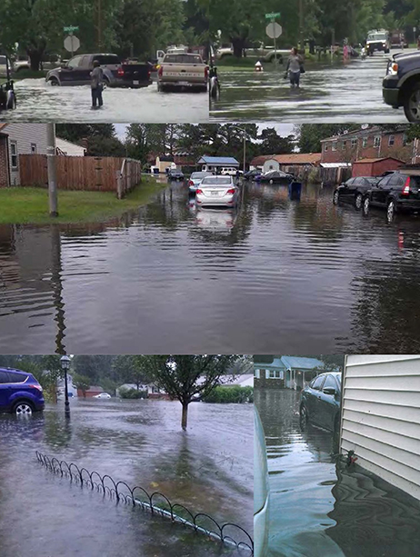
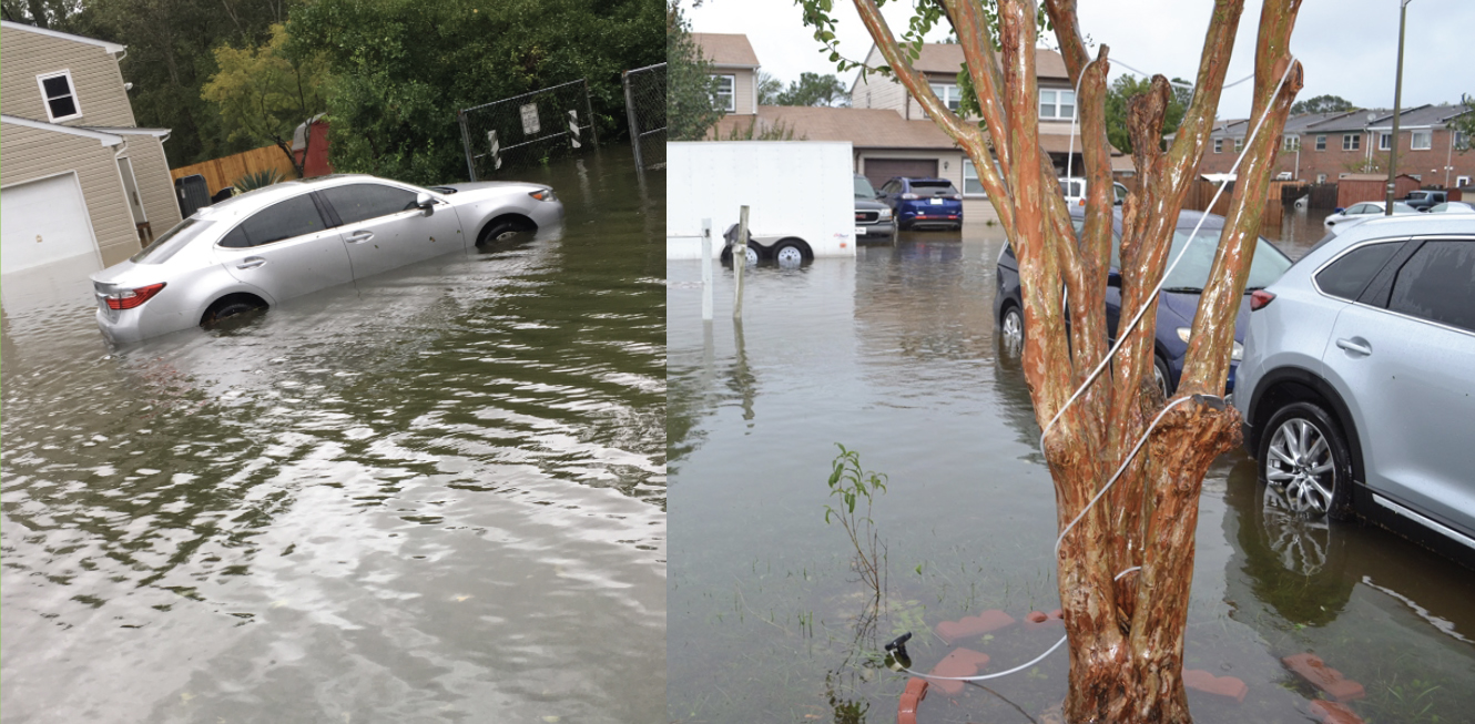
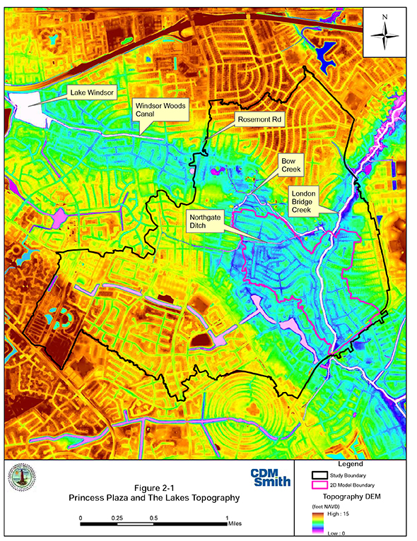
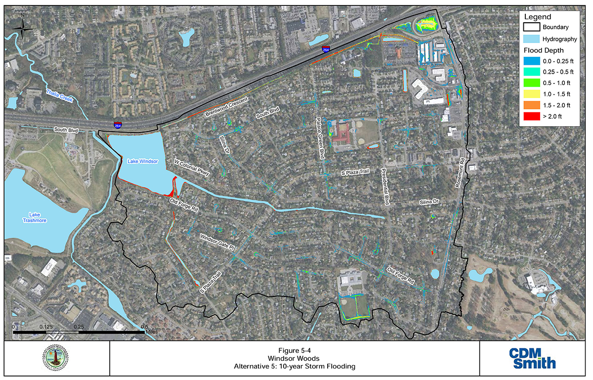
Honor Award - Environmental SustainabilityCity of Virginia Beach Stormwater Management and Flood Mitigation Planning ProjectEntrant: CDM Smith Entrant Profile The City of Virginia Beach is the most populous city in Virginia, located on the state's south- eastern coast along the Chesapeake Bay and Atlantic Ocean. Virginia Beach is almost entirely surrounded by water and permeated with lakes, rivers and marshes. The City's economy mainly relies on tourism, the military and agriculture. Being in the coastal region of Hampton Roads, Virginia Beach understands the threat of sea level rise and is preparing for the future. The City is developing plans for current and future flooding risks after seeing recorded sea level rise of nearly one foot over the past 50 years. CDM Smith is a privately-owned engineering and construction firm providing legendary client service and smart solutions in water, environment, transportation, energy and facilities. CDM Smith has over 50 years of experience in stormwater and watershed management planning and engineering, and during this time, has developed innovative state-of-the-art methods and tools to analyze water quality and quantity issues for urban development. The City of Virginia Beach selected CDM Smith to develop stormwater management system mitigation plans for multiple neighborhoods that are consistently experiencing critical flooding, including: The Lakes, Princess Anne Plaza, and Windsor Woods. In total, the study areas encompass almost 2,000 acres. Project DescriptionHeavy rain, hurricanes and Nor'easters threaten the low-lying coastal City of Virginia Beach year after year. The area has struggled with flooding from record rainfalls, including Hurricane Matthew that impacted over 1,000 homes in 2016. In response, the City expedited plans to invest in resilience for its vulnerable neighborhoods. Working with the City, CDM Smith used detailed stormwater modeling to develop comprehensive flood mitigation plans and design alternative solutions to address limited stormwater management system (SMS) capacity and impacts from downstream tidal conditions. The completed plans are the basis for ongoing engineering design the City is undertaking to implement infrastructure improvements in excess of $275 million. Integrated ApproachThe project focused on three Virginia Beach neighborhoods experiencing a mix of challenging conditions:
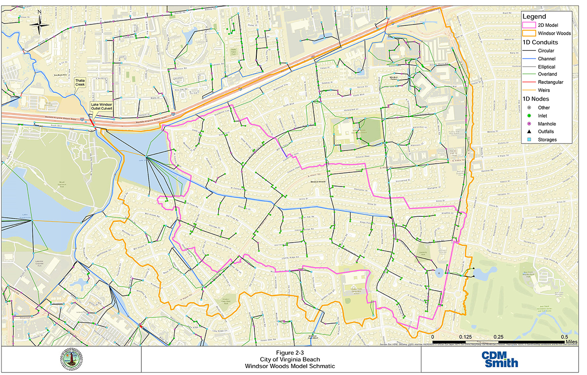
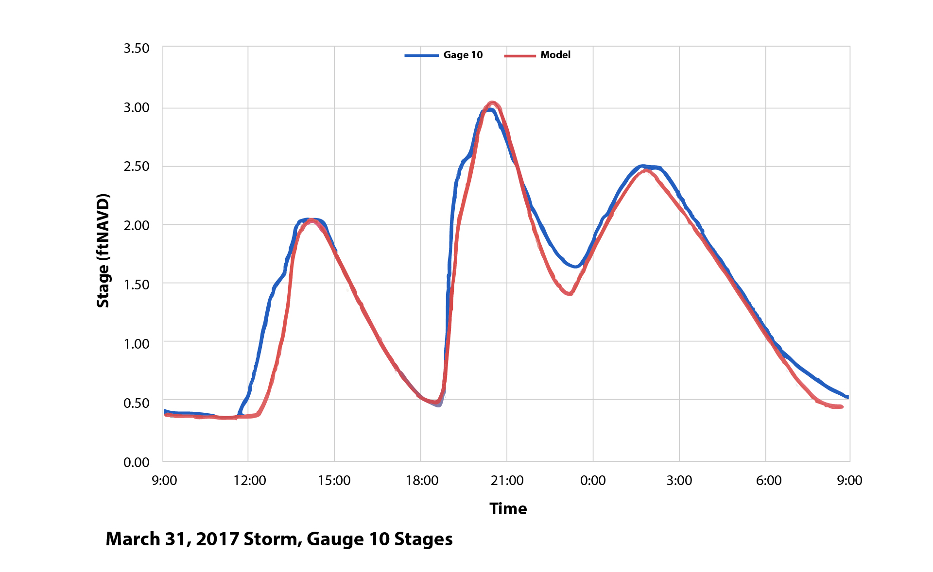
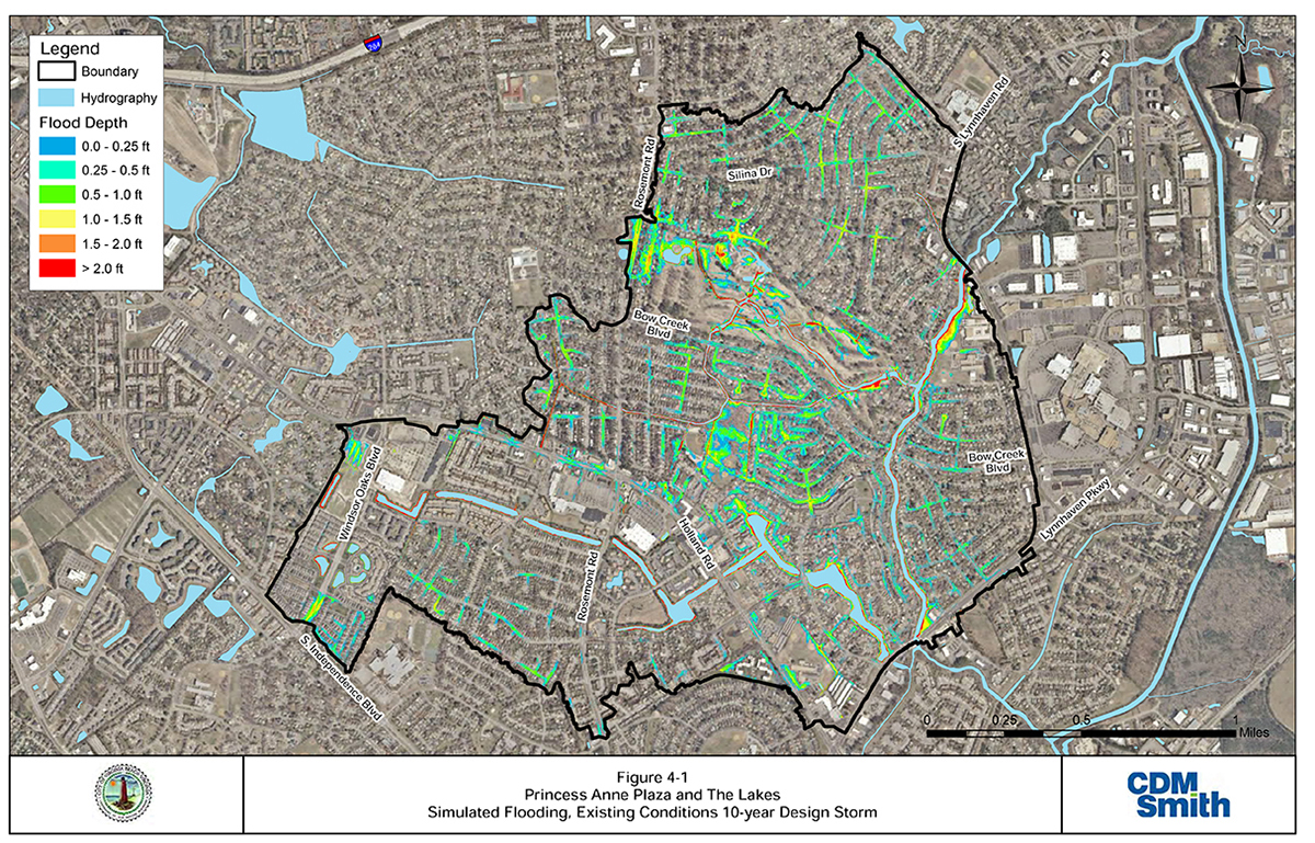
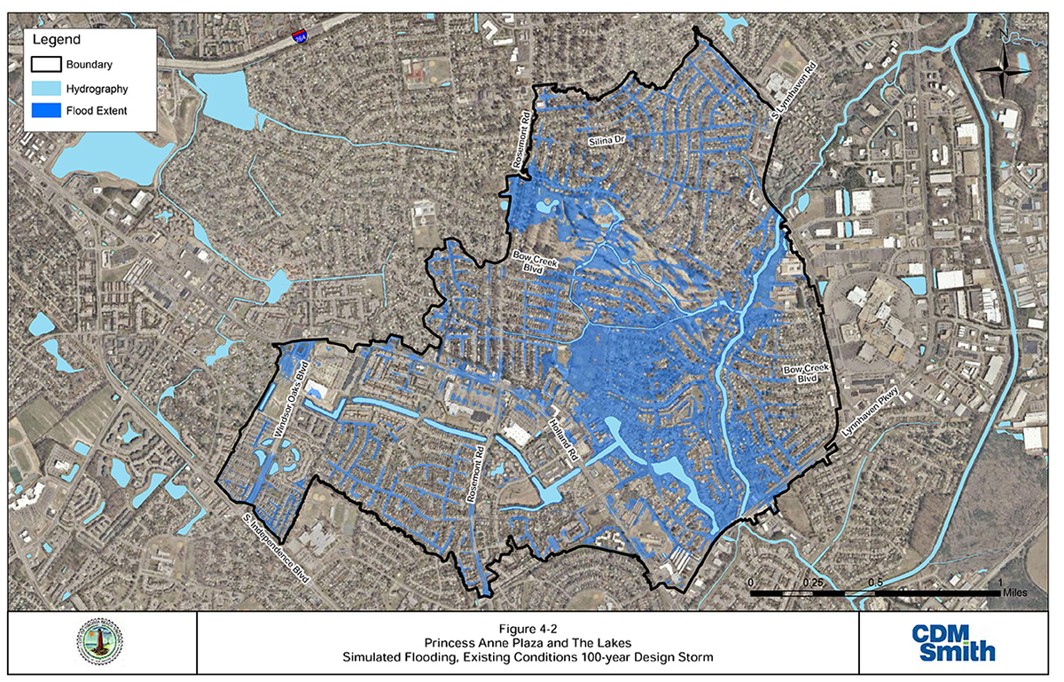
These complex challenges required an integrated approach. The project area included approximately 2,000 acres of land, surrounding drainage basins and bodies of water, including the Chesapeake Bay, lakes, ponds, canals, creeks and tributaries. In total, over 12,000 acres—18+ square miles—were analyzed to account for flow interaction, SLR and water quality. Solutions were formulated carefully so benefits to one area would not adversely impact an adjacent area. SMS improvements proposed in the mitigation plans accounted for impact to wetlands and addressed permitting requirements.> Innovative TechnologyCDM Smith developed hydrologic and hydraulic (H&H) models for each neighborhood to explore alternatives to alleviate flooding and promote resiliency. The H&H models were developed at an unprecedented level of detail for the large study area to accurately evaluate SMS performance and formulate infrastructure improvements. The high level of detail in the H&H models was purposely selected to address the sensitivity of flood damages. For example, in the Windsor Woods neighborhood, each tenth of a foot in elevation change represented approximately 50 homes. Stormwater models were developed using Computational Hydraulics International's Personal Computer Stormwater Management Model (PCSWMM) software. PCSWMM uses the U.S. Environmental Protection Agency's SWMM engine, which uses physical H&H parameters based on the best available data, engineering guidelines and judgement. Due to the extent of recurring flooding and the flat topography in the study area, both one-dimensional (1D) and two-dimensional (2D) models were developed. The 2D model used 20-foot grid spacing to effectively simulate surface storage, flow paths and flood depths at a high level of detail in the most vulnerable, extremely flat areas. Because of the computational requirements of 2D modeling, the remaining study area was modeled in 1D. The modeling approach was specifically tailored to capture the dynamic interaction between precipitation stormwater runoff and tidal conditions–an interaction that is often simplified in practice, but in this case, substantially influences existing flood extent and the ability for stormwater improvements to function effectively. Proven PerformanceModels were calibrated to multiple storms over a range of rainfall intensities and boundary conditions and validated with available storm data. These data included the City's storm complaints database, photographs and videos of flooding during rain events and field-surveyed peak flood elevations. CDM Smith successfully calibrated the H&H models to a range of observed flooding conditions caused by notable weather events, including a storm on September 8, 2014; remnants of Tropical Storm Julia on September 19-21, 2016; and Hurricane Matthew on October 8-9, 2016. Simulation of the existing SMS capacity, overland flooding and downstream tidal conditions were critical to producing accurate water surface elevations throughout the study areas. Once the model matched observed conditions, it was used to simulate the SMS response to other rainfall events—a range of 2-, 10-, 25-, 50- and 100-year design storms—SLR conditions and correlated downstream tidal boundary conditions. The models allowed the City to make informed decisions prioritizing infrastructure resiliency and sustainability projects. Neighborhood-specific mitigation plans included analysis of the existing SMS and evaluation of alternatives to reduce flooding. Alternative solutions were evaluated on their ability to meet a practical, achievable minimum level of service:
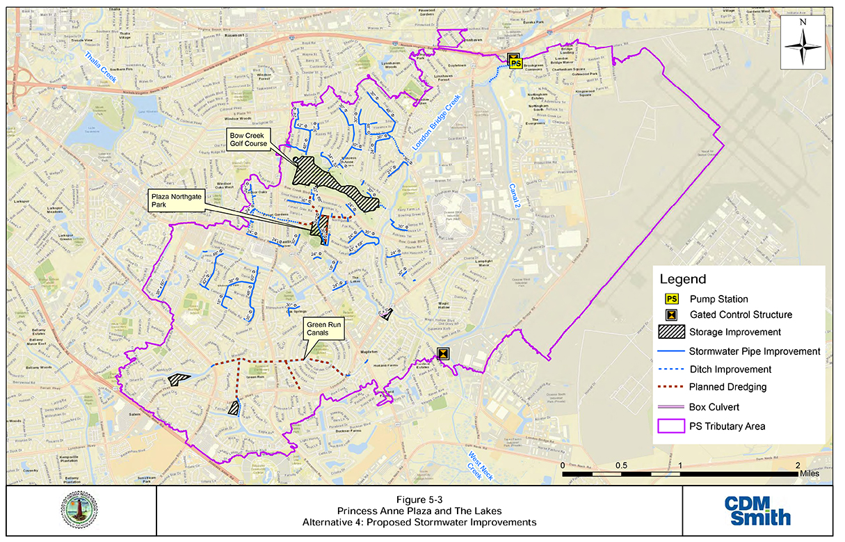
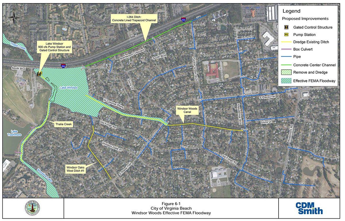
This approach offers substantial benefits with significant cost savings compared to the funding that would be required to meet all current design standards. SolutionsMitigating flooding in a low-lying area 10 miles from the coast without impacting downstream areas posed a complex technical challenge. CDM Smith provided both short- and long-term solutions for Capital Improvement Program planning. Immediate, readily correctible issues would restore the SMS to its original capacity and included:
Longer-term flood mitigation options, requiring more extensive design, permitting and investment included:
CDM Smith provided planning-level opinion of probable construction cost (OPCC) for each study based on a conceptual level of detail. Social and Economic AdvancementThe completed engineering evaluations and recommended mitigation plans assisted Virginia Beach to quantify infrastructure improvements necessary to protect highly vulnerable neighborhoods, understand the financial investment in critical stormwater management infrastructure and promote the public stability necessary for public/private renewal, redevelopment and reinvestment. The mitigation plans were a key component in the City's long-term plan to address SLR, which was necessary to maintain bond ratings, promote confidence with private investors and preserve property values in established neighborhoods within the community. Planned safety measures provided substantial protection from flood damage to homes and structures and maintained emergency vehicle access to roadways. Click images to enlarge in separate window.
Click here to return to the list of 2020 winners. |
Our Partners